Looking west from South Baldy, Kananskis Country

Looking west from South Baldy, Kananskis Country

Saturday 31 October 2015

EEOR at last!


The East End of Rundle (EEOR) had eluded me for a few months. I'd planned to do it a couple of times previously, but injury, work, or the sight of huge black clouds over the mountains had put me off. We grabbed the opportunity on Halloween, and I was very glad that we had, because winter was certainly starting in the high mountains.

On the way up we noticed some people prospecting for a new route up the cliffs halfway between the ridge (aka the Daffern route), and the gully to its left (aka the Kane route). At least, that's what I assume they were doing.... There was one mountain goat in the party, who managed to climb impressively high up the wall, before having to return to the others, who seemed less keen on the idea of climbing up 15 m of steep, snow-slicked limestone. I'm not sure what was going on up there, but eventually they all turned around and headed down, which was a relief, because the rocks were pretty slippery from overnight snow. The Kane gully was OK, if a little treacherous underfoot.

The summit - well, summits really, since our two most eminent local guidebook authors have been allotted one each - was cold and windy, but a great place to be today. Descending the ridge gave some cause for thought; what must be a staircase in dry conditions had become an invitation to the fastest ride in the Nordic Centre. We took our time, brushing snow from each hold. A summer of hiking had clearly made us soft!

I'm just so down with the kids. Thoughtful moment on the descent


Looking across the ascent path, to Ha Ling

Sunday 25 October 2015

A Fall Paddle from Canmore to Dead Man's Flats

The canoe jolts suddenly, struck below the waterline by an unseen and uncaring submerged tree, dead for several seasons. I throw my weight to counter, but I'm too late, and the last thing I see is the wetly gleaming hull of my boat as it rolls like a breaching whale, pitching me into the freezing black water, and pushing me under. Shockingly cold water steals my breath in an instant. As I kick out to clear myself from the boat and return to the surface, my legs are clasped by sharp spindly fingers, and the indifferent water surges downwards, twisting and folding me under slick, unyielding branches. Stirred silt wells up, the encroaching clouds casting a sudden twilight. From this forgotten forest the flickering mountains are impossibly distant. Somewhere above the surface in the clean blue air of fall, my companions watch in horror and hope as my waterlogged boat circles lazily into a safe eddy like a loyal returning dog, but the string of bubbles that flows from beneath the strainer soon stops, and the mountains' reflections are repaired.

Both times that I have paddled from Canmore to Dead Man's Flats I have been glad of the low water that characterises fall on the Bow, because there is a stretch that involves threading a narrow channel between logjams, and avoiding sweepers. The name "Dead Man's Flats" relates to a local fratricide, rather than a drowning, but I have heard of at least one nasty entrapment occurring in a sweeper here. Fortunately, that one ended well, but be warned! The river splits into several small channels, most of which are not safely navigable. In low water, it may be easy enough for an appropriately skilled paddler to dawdle along, working out the correct route, and portaging where necessary. In higher flows, however, this can be much more difficult - and potentially deadly. Beware also that conditions change every year, and it would not take much for a new hazard to close the existing routes. Perhaps I'm playing up the danger a bit, but I'd hate to hear of anyone else getting into difficulty on this reach, when the hazards have been well-publicized.

Classic canoe, classic setting.

This is AFTER the tight section, showing further sweepers in a narrow channel. The sweepers are accompanied by underwater logjams.

We had perfect conditions in late October 2015. Blue sky, no wind, and low water. Lou took her new little lightweight boat, and enjoyed trying it out on moving water.

Spot the Australian. Ruffians. Lou and Ha Ling.
This is one of the most scenic local paddles. If it were not for the sweepers, it might even be more popular than Banff-Canmore, although the noisy TransCanada highway is never far away, and at one point on the most recent trip we heard gunshots not far to the south. We were fortunate to be shown the correct channel a few years ago by a friend and Canmore local. Without that knowledge, it would be easy to end up in a logjam. Thanks Don!

Paddling past Grotto Mountain Mike, Jack and Betty.
Unfortunately for Mike, this trip led to a sad parting with his favourite camera. While drifting backwards and setting up for an upstream shot, his boat closed on a midstream log. Lindsey and Mar shouted a warning, but as he reacted, the camera went overboard. There followed a few minutes of frantic, and eventually successful, river searching by various party members, but the post mortem indicated drowning to be the probable cause of death.

Mike and Suzanne paying "hunt the DSLR" Lou in her little red boat.
Trip Details

Canmore to Dead Man's Flats
Sweeper and logjam hazards - low water preferable.
Allow about five hours.
Guidebook: Mark’s Guide for Alberta Paddlers


Sunday 16 August 2015

A Snowy Wet Day on the Headwall and Chester Lakes Circuit


Looking back up the Chester valley. Mt Chester and friends are up there somewhere!

This is an amazing hike, and one that I shall certainly do again. Far from spoiling the day, the threatening skies and heavy rain high in the Headwall Lakes valley just improved the atmosphere.
Headwall Lakes Valley
Lower Headwall Lake. The trail climbs the headwall on the right
No trickery - the mountains really are stacked like books falling from a shelf!
I'd been to Chester Lakes before, so we opted for the anticlockwise circuit, climbing up through Headwall Lakes, then over the Fortress col, and descending via Chester Lakes. This proved to be excellent, and I'd repeat it in the same direction.
It's a long way!
Amanada, just before the rain hit us
The slow and loose haul up to the Fortress Col. 
By hiking the route anticlockwise, you avoid a lot of the crowds, and the grind up to the Fortress col is completed on firmer scree. There were some out-of-control people on the descent from the col, and although it offered a fun, fast descent, I was aware of the potential for a needless incident involving loose rocks and/or flying bodies. With the cloud down to around 2,700 m there was no point in continuing to the Fortress just for the sake of summiting, so we rolled back to the parking lot, pleased to have enjoyed such a beautiful valley.
This is one of the most lovely valleys I've hiked in the Rockies. It reminded me of Arran.
Me on the col
The Fortress beyond the col

Saturday 25 July 2015

Rain on Wind Ridge

British conditions on Wind Ridge
Wind Ridge is one of those hikes that I drive past every time I go to Canmore or beyond, and that make me wonder what's up the next valley.

It's a straightforward outing, once you get past the initial flood damage and cross a creek via a slightly precarious makeshift bridge. The angle is steep, as befits all of the Bow Valley hikes I've done so far, but unlike most of the country in this area, there are lush meadows and flowers to look forward to.

I hiked this trail with my Australian friends Mike and Suzanne. It was their first Rockies hike, and I think we chose a pretty good one, although higher up the rail gets a bit washed-out. I'm not sure whether this is due to the hike becoming more popular of late, but on the trail, the topsoil is now being eroded through to bedrock, by rainfall runoff. There are few zigzags; that may be part of the issue.

The weather threatened something special all the way up, and by the time we left the forest, the wind was whipping up huge black rain-clouds and trail dust with equal enthusiasm. I hadn't been out much lately, so I was keen to get to the top if possible.

After the meadows there was a little scrambling step. Suzanne decided to stop there and enjoy the view while we continued to the top. Shortly after we got up the step, the weather turned decidedly British, but by the time we'd met up with Suzanne and reached the valley floor, the ground was steaming, and the skies were clear.

Alpine meadows below the summit


For a full description of this hike, refer to Gillean Daffern: Bow Valley and Ghost volume.
Toiling up against the wind; Windtower provides a fitting backdrop. The low cloud added a different feel to the hike.

Wednesday 15 July 2015

Joy in Kananskis Country

The “Kananskis Obscure” guide is a quirky online catch-all for routes that are considered outside the reach of current guidebooks, either geographically, or because they were new at the time of the guide’s creation. It’s like a proving ground for new climbs; the one that make the big time find their way into print elsewhere.

Unknown climber out on the slab above Upper Kananaskis Lake.

Joy (~2,000 ft, 5.6+) is one of those climbs. When I first heard of it, it was still pretty obscure. Now it’s a three (or however many you feel like awarding) star mainstream classic. We shared it with two other parties, but were fortunate to find our skills complementary, in that one party was from the Alps, and extremely fast, while the other comprised two guys who appeared still to be in the invincible phase of adulthood. They climbed way out on the edge of the slab for much of the route, frequently placing just one or perhaps two runners in an 80 m rope length. The old, slow guys (us) plodded happily up the corner, placing gear every five metres or so, and generally enjoying the situation. I think everyone had a good day.

The route follows the corner slightly right of centre, starting on the far-left of the photo, below the trees.
We had perfect conditions in late October 2015. Blue sky, no wind, and low water. Lou took her new little lightweight boat, and enjoyed trying it out on moving water.

At the start of the lovely cracks. Looking down the route from the top of about the sixth pitch.
John Moreland high on Joy.
About halfway up, black clouds started to appear from over the summit of Mt. Indefatigable, and a few spots of rain fell. We had a tense twenty minutes or so, before the clouds moved away. Descent would be, at best, problematic.

My favourite pitch. 
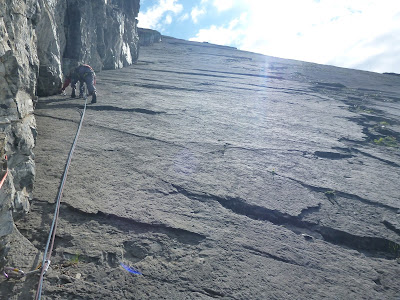
Typical climbing. There's a lot of it!
As we got higher, the climbing became more varied, and easier. With the clouds moving away for now, we relaxed, and enjoyed the final pitches.

John Moreland in a corner, nay, the corner!
Hello! This little chap was very curious about my belay wires. Beautiful alpine meadows on the descent.
The descent was steep, but beautiful, passing through high alpine meadows full of flowers. Access in this area is ostensibly restricted due to bear activity, but we saw no scat, no tracks, no digging, and no bears. Weird.

Taking a break in sunshine on the way down. The path descends the high valley to the left, and cuts right across the rock buttress. It's quite devious. Upper K Lake from the final pitch.
Trip Details

Joy, rock climb. 5.6+
Upper Kananaskis.
Watch for good weather!
Guidebook: Canadian Rock: Select Climbs of the West


Saturday 11 July 2015

Tracy's Action-Packed Week in the Rockies


We were delighted to have a visitor for a week in July, when our friend Tracy flew up from Seattle.

We knew this might be her last chance to visit, because she had recently accepted a job in Rotterdam. We decided to make the most of the week, and show her around the area, doing some of the fun things that we'd discovered over the past few years.


Bowmont Park


First up was a mountain bike ride through Bowmont Natural Area, with what's become the traditional local photo when we have visitors: Bowness railway bridge, the river, and distant mountains. Check.

We went to the Stampede Art Show launch, where our friend Karen shows her amazing wildlife photography every year, then on into town. This was a bit unusual; it's a self-fulfilling prophecy that nobody goes into town for the evening or weekend in Calgary! Lou had found a small restaurant in a park that turned out to be really good. The whole experience was rather un-Calgarian. There were hipsters in the park, and everything. Even a man on a horse, like the one back in Wolverhampton, but this one was probably not a Prince - and I'm sure he'd not seen a fraction of the excitement that occurs in Queen's Square...

Crossing the Spray River. View from the second bridge on a lovely day
The next day we headed into the mountains, and Lou kindly dropped us at the head of the Goat Creek Trail above Canmore, before parking in the town and riding the Legacy Trail (a 20 km paved route with almost no hills, and a lot of scenery) to Banff. Meanwhile, on the other side of Mount Rundle from her, we rolled joyously down the trail, crossing and then following the Spray River. Tracy had never ridden a mountain bike until the Bowmont trip, so this was a great experience. We reunited in Banff for a late lunch, with Pizza and real ale, sorry, "craft beer", and then wobbled our way back together on the Legacy Trail. I was pleased to see that Canmore has now finished the trail, and laid on a handy parking lot for cyclists, just on the edge of town.

The next trip was also from Banff, but this time we were on the lowest point in the landscape, canoeing from Bow Falls to Canmore. If you're going to visit Calgary in the summer, then you have to include at least one canoe trip!

There was still something missing though. We'd paddled, cycled on- and off-road, eaten great food, drunk some excellent beer,
and even been downtown at the weekend (I still can't remember why!) - so the final mini-adventure had to involve climbing - rather than merely walking up - a mountain.

Approaching the first scramble (of Tracy's lifetime)

Sizing up the step. It's easier than it looks.
Yes, we're going up there!
Nihahi Ridge was identified as the perfect first scramble for Tracy, in a week of new things. It starts off as a pretty little walk, wending through meadows, towards an impossibly distant, soaring red ridge. Then before you know it, with a quick double-switchback, it throws you up above the valley, and pins you against the wall, with only one way up.

Looking back towards the first scramble step, from close to the second
Fortunately, Tracy took the whole thing in her stride, and before long we were tripping along the knife-edge ridge that's the reward for the earlier effort. Great job! I don't think they'll have anything like this in Holland...


Monday 18 May 2015

A Typical Bank Holiday Weekend in Waterton Lakes National Park

If you want to know when it's going to snow or rain in Alberta, just look up the dates of the long weekends! Normally I don't bother trying to go camping at May Long Weekend, because it's a soggy zoo. This year I told myself not to be so cynical; I loaded a solo open boat onto the car and headed down to Waterton Lakes National Park with the Bow Waters Canoe Club.

And how did the weather repay me for my conversion to optimism?

Well, first it did this:

Four inches of heavy wet snow fell on the Friday night. My trusty Crux X2 tent has survived appalling conditions over the last ten years. The snow was so heavy (it was like a wet cement shell on the roof), that the flysheet sprang a leak, and dripped on me all through the night. But that did not stop us from paddling. Here's Tina looking a lot more excited about the prospect of paddling than Bosco the dog does. His day improved greatly when he returned from a beach-break and jumped into the boat carrying a severed, rotting deer's leg though. Good boy! :-)

Looking back, I have hardly any pictures from this trip; it was just too wet and cold! The weather got worse; it rained heavily on Saturday, while we paddled the St. Mary River. The access road became a mudbath that required one of the members to drag four other vehicles (trucks and SUVs, all with 4WD) up the hill using her offroad 4WD. Then I had a near-miss when a huge rock (several times my weight) was released by erosion, and bounced ten metres down the river cliff to land a few metres from my boat. The paddling itself was fine, but the weather really had it in for us.

Fortunately, the Belly River Group Campground has a cook shelter containing a large wood-burning stove. By cranking it up until the chimney glowed, we were able to turn the building into a huge sauna, and dry out all of our gear each evening. That was impressive given how wet things got. Without it, I'd have headed home on Saturday night!

Neil and Sue smiling despite the cold Tina was excited about everything, as usual. Tina and Bosco, minus deer.
Our trip down the Belly River was cold, but at least it had stopped raining. By Monday, when the few of us that still had the energy headed to the Waterton River, it was warming up. Here we hit another weather-related hazard though; a dam had failed, washing out the access road. Instead of driving to the put-in, we had to abandon the vehicles and run the dam outflow (watching for barbed wire and sweepers) until it connected with the river. That was actually a fun little diversion which involved lowering the boats over a small cliff, then some lining and rock dodging in soupy water.

Lining below the former dam. More lining.
And a bit of paddling!

I went home exhausted. I was pleased to have got three days of solo paddling under my belt, and seen three new rivers, but my aversion to Alberta May long Weekend had been reinforced!