Looking west from South Baldy, Kananskis Country

Looking west from South Baldy, Kananskis Country
Showing posts with label kananaskis. Show all posts

Friday, 29 July 2016

North Ridge of Moose Mountain

A Hike-a-Bike up Moose Mountain's North Ridge

Moose Mountain occupies a huge sector of Calgary's mountain panorama. Most people who hike or bike up it do so from the southern well road ("the Moose Mountain Road"), off Highway 66. The problems with that are that: 

- It is a crowded route;
- Unless approaching via the Pneuma or Moosepacker trails, you miss out most of the ascent; and
- It only takes in part of Moose Mountain's skyline.

I'd done the tourist route many times, and had always regarded the other ridges with interest. This is my brief account of taking the North Ridge approach.

The route is described by Gillean Daffern, although this is a trip for which her compound approach to descriptions caused me some confusion. IMO it's best to just use the Gem Trek map, and forget the book, unless you want to extend the day substantially by taking cut lines etc. instead of the direct approach.

From the Pine Woods picnic area (washroom and non-potable water pump) we immediately took the wrong route. The map suggested that we could descend to a creek directly underneath the parking area, then pick up a cut-through trail to the Husky well road that would take us to the end of the biking section. Unfortunately, the 2013 flood removed a bridge here, so we started the day with wet feet. If you do this route, ride north from the parking lot for 500 m, until you reach the gated well road junction, then descend to a bridge, and continue towards Moose Mountain.

The road is about 14 km long. At least 13 km of it is uphill, and I ended up walking several times. The extra weight of hiking gear, boots, and water made quite a difference. Eventually, after passing several oil and gas facilities, we skirted the main site (the only staffed facility), and continued for 2 km uphill to the col and well pad below the north ridge. Partway up this leg, we noticed a cairn that I believe marked the faint trail to Jumpingpound Mountain. We dumped our bikes behind a berm, changed, and headed off uphill through some lovely meadows that offered great views. 

Cycling up the road to Moose Mtn North Ridge
Moose Mountain's north ridge, leading to the summit, seen from the interminable well road.
Hiking moose mountain
On the meadows where the North Ridge kicks up. It's raining in Calgary!
The summit of the North Ridge is only a little lower than the main summit.
The north ridge turned out to be a pleasant almost-scramble, along a narrow rocky ridge. Part way along there was a shovel standing upright in a cairn. I've asked around, but nobody seems to know the story behind this oddity. It's been there for a good few years.

Moose Mountain north ridge
Andy descends from the main summit, passing a memorial stone.
The final few metres were fairly steep, but the footing is OK, and after a short climb, the ridge met the main trail. On the descent we noticed a memorial stone (it's down past the fire lookout's biffy, if you want to take a look). 

Moose Mountain North Ridge
Lovely meadows on the descent, near the well pad.
The descent was insanely fast. Overall the trip included around 29 km of riding, and 4 km of hiking. It's not a long day per se, but the continuous uphill grind on the bike is sure to take its toll. Fortunately Andy had sneaked a couple of chilled beers into his cooler, so getting into the baking-hot car afterwards was a little easier than it might have been.

Friday, 10 June 2016

My First Sister: Middle Sister, Canmore

three sisters

I have a bit of a ticking campaign in motion this year. I'm trying to climb the peaks that are visible along Highways 40 and 1, between the Highwood Pass and Banff. There are quite a lot of them, and some are probably too hard/loose/obscure, but prominent in anybody's list of notable summits would be the Three Sisters, which have featured in numerous books, films, and pub patio views over the years. Of the three, Big Sister is the highest, Little Sister the most difficult, and Middle Sister the most distant from the road.

The trail begins with a painful detour around a construction site and golf course that threatens to add ~5 km to your day. The access constraints seem to change monthly, and at 8 AM on a Sunday, you're unlikely to see too many property developers or golfers (which are essentially the same species), so I shan't describe the start. Once you're in the Stewart Creek canyon, the trail soon vanishes under flood debris, and you're in for 6 km each way of climbing over boulders. It was hot on the day we did this - around 32 C in town - and we carried a lot of water. The creek was flowing, but you never know when it'll dry up for the summer. If you decide to rely on it, bear in mind that we saw two marmot colonies living right alongside the water, so you'll likely want to filter the water for nasties.

three sisters
Little Sister seen from partway up the ascent of Middle Sister

We began the trip with a dislocated shoulder just 100 m from the golf course. Mike was in a bit of pain from this, but fortunately it popped in just as suddenly as it had come out, and he could continue, but without his poles. He gave those to Jason, who was lacking his own poles due to an incident involving a kleptomaniac marmot and a video camera. It was a great film, but it came at a price...

The crux of the hike is an erosion scar on the left-hand bank just before a grassy ridge is attained. The ground is pretty scrabbly, and it's easy to shower your group with loose rocks. Poles help a lot. Above this, the ridge is a pleasant place to sit and admire the view. The next part is a scree slog, and passes under 500 m or so of early-season objective danger. The slopes of Big Sister hold snow and boulders, which become mobile after a few hours of sunshine.

middle sister
Jason on the grassy ridge

middle sister
Starting up the scree approach to the ramp

The scree continues up a giant ramp for about a kilometre, right to the summit - which is the farthest point that you can see on the way up, and the last point on the ramp before the impressive cliffs that separate Middle and Little Sister. The apparent height difference between them when seen in classic profile is an optical illusion; there is actually very little vertical difference, whereas Big Sister appears to be a long way above you. From the summit of Middle Sister we traced the line of the easiest ascent route, which is a rock climb graded about 5.3. It looked unpleasantly loose, and the approach would be a bit of a pig. That objective instantly slipped down my hit list! The views towards Commonwealth Peak and Mt Bogart were excellent.

While relaxing on the summit, we saw an avalanche cascading down Big Sister from slopes similar to those that threaten the Middle Sister ramp. On the descent, we sped as fast as possible down the exposed section, not stopping until we reached the safety of the grassy ridge opposite.

avalanche
Avalanche on Big Sister

middle sister
Looking back down the ramp during our ascent.

middle sister
It feels like a long way up the ramp

Still ascending

Ixta and Serena glad to have reached the easy ground before the summit

middle sister
Mike celebrating an ascent of a Canmore hiking icon

three sisters
Jason and Big Sister

middle sister

Mike pulled out his rather whiffy Mountain Obsession flag for the summit photo, with Little Sister in the background

middle sister
Natasha begins the scenic descent, looking into southern K Country

Ixta enjoying the sun with many waterfalls in the background

Because we were a large group (six people) we wanted to avoid the loose crux slope. We followed a vague trail into trees to the east of it, and spent a questionably enjoyable few minutes fighting our way down steep ground, unable to see our feet. It was safer, but not very pleasant. At least there was no Devil's Club to contend with, though! Afterwards, all that remained was the trudge back down Stewart Creek, rounding off 18 km of rough hiking and 1500 m of ascent. Mike celebrated with an agonizing cramp in his legs, just shy of the golf course. I'd told him earlier that golf courses are evil places, and here was the proof!

middle sister
Mike's jungle adventures...

Saturday, 2 April 2016

(Yet another way up) Midnight Peak

Peering into the drainage, where many options are available.

Midnight Peak

Midnight is an unofficial peak, meaning that she is denied recognition on government maps. Despite her exclusion from the higher stratum of mountain society, Midnight gets around the scene, having made wildcat appearances on most of the local scramblers' blogs, plus printed stabs at semi-official acknowledgement in the pages of Gillean Daffern and Andrew Nugara's guides. Sometimes she brings along her smaller and more enigmatic cousin Midday, or Half-Past Midnight. I've yet to hear her Midday referred to as Li'l Midnite yet, but who knows? Unofficial peaks are exciting and experimental!

With prescribed routes absent from the map, the mountain has become a blank canvas. A quick scan though my usual scrambling blogs revealed that almost every recorded ascent took a different line, and if we added them all to one map we'd probably have to change her name to "Spiderweb Peak". It was fitting that our ascent yesterday should oscillate uncertainly between at least five options, before striking up an unclaimed, unnamed line.

Our initial plan was to ascend the black ridge on the far-right skyline in the photograph to the left, but we were rebuffed by a deep patch of snow that appeared to be four inches of wet slab sitting on two feet of sugar. So we crossed the drainage and wandered up slabs and over scree, before being bounced like a pinball off the left-most ridge of the valley, and careening back onto the blunt middle rib that divides the two main snowy drainage bowls. Several routes up the mountain via these various features have been described online.
Mike on the rising slabby traverse, with West Baldy behind him.

Typical terrain in the upper drainage.

Grinding upwards in spring sunshine.


Descending a short, slippery snowfield on the northeast ridge route.

Trip Details

Midnight Peak scramble
~950 m, 9 km.
Starting point: highway 40
There are many unofficial routes online; choose one, or make your own!
The ascent is 950 m, but as my hiking partner Mike observed, "the GPS only records upwards progress, not the step that you slide backwards for every two taken forwards." He had a point; the deep snow low in the drainage, and shattered rock higher up definitely sapped energy in amounts disproportionate to the height of the summit.

Atypically, our line-of-best-fit dumped us just a stone's throw from the summit of Midnight Peak, where Mike, arriving second, was delighted to find a pair of new-looking walking poles abandoned behind the summit cairn. We took photos, and he admired the nerve of the "crazy f******" who had left a line of prints down the narrow, snowy ridge that dropped away the northeast. The dismay imparted by the news that this was to be our descent line was compounded when I retrieved my hiking poles from his bag.


We blamed the latter misunderstanding on the altitude, which apparently they don't have in Australia.
midnight peak scramble
Hands on shattered rock near the summit ridge.


Mike enjoying the spacious summit.


Looking west. Summer and winter straddle the ridge.

joe lenham
Starting down the short ridge on the descent.

We pulled out our ice axes for fifteen minutes on the descent. I have to admit to being the first to reach for mine as soon as the snow is thick or hard enough, but twenty years ago I experienced what even a short slide can lead to, and I have no desire to repeat the lesson. I seldom see people here using theirs; this makes me wonder how many shoulder season scramblers have spent time throwing themselves down a snow slope with a safe run-out. When things go south, you tend not to stop until you hit something hard, at speed.

Monday, 15 February 2016

A Season Begins on Eagle Hill

Deserted forest walking The snow was almost gone already!

Not my season - I'd managed to get out a couple of times this year already - but Lou's. This year I was here a month earlier than in 2015, and there was far less snow. Unlike my last visit, when we struggled to face the mountains, this year the wind wasn't too bad. It had the feeling of a lovely spring day, but we saw just one hiker on the trail.

Trip Details

Eagle Hill - about 9.5 km, ~200 m.
Starting point: Sibbald Creek Rd.
More info online - Bob Spirko.. Guidebook: Gillean Daffern: Kananaskis Valley volume

Saturday, 25 July 2015

Rain on Wind Ridge

British conditions on Wind Ridge
Wind Ridge is one of those hikes that I drive past every time I go to Canmore or beyond, and that make me wonder what's up the next valley.

It's a straightforward outing, once you get past the initial flood damage and cross a creek via a slightly precarious makeshift bridge. The angle is steep, as befits all of the Bow Valley hikes I've done so far, but unlike most of the country in this area, there are lush meadows and flowers to look forward to.

I hiked this trail with my Australian friends Mike and Suzanne. It was their first Rockies hike, and I think we chose a pretty good one, although higher up the rail gets a bit washed-out. I'm not sure whether this is due to the hike becoming more popular of late, but on the trail, the topsoil is now being eroded through to bedrock, by rainfall runoff. There are few zigzags; that may be part of the issue.

The weather threatened something special all the way up, and by the time we left the forest, the wind was whipping up huge black rain-clouds and trail dust with equal enthusiasm. I hadn't been out much lately, so I was keen to get to the top if possible.

After the meadows there was a little scrambling step. Suzanne decided to stop there and enjoy the view while we continued to the top. Shortly after we got up the step, the weather turned decidedly British, but by the time we'd met up with Suzanne and reached the valley floor, the ground was steaming, and the skies were clear.

Alpine meadows below the summit


For a full description of this hike, refer to Gillean Daffern: Bow Valley and Ghost volume.
Toiling up against the wind; Windtower provides a fitting backdrop. The low cloud added a different feel to the hike.

Wednesday, 15 July 2015

Joy in Kananskis Country

The “Kananskis Obscure” guide is a quirky online catch-all for routes that are considered outside the reach of current guidebooks, either geographically, or because they were new at the time of the guide’s creation. It’s like a proving ground for new climbs; the one that make the big time find their way into print elsewhere.

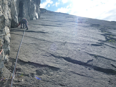
Unknown climber out on the slab above Upper Kananaskis Lake.

Joy (~2,000 ft, 5.6+) is one of those climbs. When I first heard of it, it was still pretty obscure. Now it’s a three (or however many you feel like awarding) star mainstream classic. We shared it with two other parties, but were fortunate to find our skills complementary, in that one party was from the Alps, and extremely fast, while the other comprised two guys who appeared still to be in the invincible phase of adulthood. They climbed way out on the edge of the slab for much of the route, frequently placing just one or perhaps two runners in an 80 m rope length. The old, slow guys (us) plodded happily up the corner, placing gear every five metres or so, and generally enjoying the situation. I think everyone had a good day.

The route follows the corner slightly right of centre, starting on the far-left of the photo, below the trees.
We had perfect conditions in late October 2015. Blue sky, no wind, and low water. Lou took her new little lightweight boat, and enjoyed trying it out on moving water.

At the start of the lovely cracks. Looking down the route from the top of about the sixth pitch.
John Moreland high on Joy.
About halfway up, black clouds started to appear from over the summit of Mt. Indefatigable, and a few spots of rain fell. We had a tense twenty minutes or so, before the clouds moved away. Descent would be, at best, problematic.

My favourite pitch. Typical climbing. There's a lot of it!
As we got higher, the climbing became more varied, and easier. With the clouds moving away for now, we relaxed, and enjoyed the final pitches.

John Moreland in a corner, nay, the corner!
Hello! This little chap was very curious about my belay wires. Beautiful alpine meadows on the descent.
The descent was steep, but beautiful, passing through high alpine meadows full of flowers. Access in this area is ostensibly restricted due to bear activity, but we saw no scat, no tracks, no digging, and no bears. Weird.

Taking a break in sunshine on the way down. The path descends the high valley to the left, and cuts right across the rock buttress. It's quite devious. Upper K Lake from the final pitch.
Trip Details

Joy, rock climb. 5.6+
Upper Kananaskis.
Watch for good weather!
Guidebook: Canadian Rock: Select Climbs of the West


Saturday, 11 July 2015

Tracy's Action-Packed Week in the Rockies


We were delighted to have a visitor for a week in July, when our friend Tracy flew up from Seattle.

We knew this might be her last chance to visit, because she had recently accepted a job in Rotterdam. We decided to make the most of the week, and show her around the area, doing some of the fun things that we'd discovered over the past few years.


Bowmont Park


First up was a mountain bike ride through Bowmont Natural Area, with what's become the traditional local photo when we have visitors: Bowness railway bridge, the river, and distant mountains. Check.

We went to the Stampede Art Show launch, where our friend Karen shows her amazing wildlife photography every year, then on into town. This was a bit unusual; it's a self-fulfilling prophecy that nobody goes into town for the evening or weekend in Calgary! Lou had found a small restaurant in a park that turned out to be really good. The whole experience was rather un-Calgarian. There were hipsters in the park, and everything. Even a man on a horse, like the one back in Wolverhampton, but this one was probably not a Prince - and I'm sure he'd not seen a fraction of the excitement that occurs in Queen's Square...

Crossing the Spray River. View from the second bridge on a lovely day
The next day we headed into the mountains, and Lou kindly dropped us at the head of the Goat Creek Trail above Canmore, before parking in the town and riding the Legacy Trail (a 20 km paved route with almost no hills, and a lot of scenery) to Banff. Meanwhile, on the other side of Mount Rundle from her, we rolled joyously down the trail, crossing and then following the Spray River. Tracy had never ridden a mountain bike until the Bowmont trip, so this was a great experience. We reunited in Banff for a late lunch, with Pizza and real ale, sorry, "craft beer", and then wobbled our way back together on the Legacy Trail. I was pleased to see that Canmore has now finished the trail, and laid on a handy parking lot for cyclists, just on the edge of town.

The next trip was also from Banff, but this time we were on the lowest point in the landscape, canoeing from Bow Falls to Canmore. If you're going to visit Calgary in the summer, then you have to include at least one canoe trip!

There was still something missing though. We'd paddled, cycled on- and off-road, eaten great food, drunk some excellent beer,
and even been downtown at the weekend (I still can't remember why!) - so the final mini-adventure had to involve climbing - rather than merely walking up - a mountain.

Approaching the first scramble (of Tracy's lifetime)

Sizing up the step. It's easier than it looks.
Yes, we're going up there!
Nihahi Ridge was identified as the perfect first scramble for Tracy, in a week of new things. It starts off as a pretty little walk, wending through meadows, towards an impossibly distant, soaring red ridge. Then before you know it, with a quick double-switchback, it throws you up above the valley, and pins you against the wall, with only one way up.

Looking back towards the first scramble step, from close to the second
Fortunately, Tracy took the whole thing in her stride, and before long we were tripping along the knife-edge ridge that's the reward for the earlier effort. Great job! I don't think they'll have anything like this in Holland...