Looking west from South Baldy, Kananskis Country

Looking west from South Baldy, Kananskis Country

Wednesday 22 July 2009

Night on Moose Mountain

Ian on the last zig-zagThe closest Rocky Mountain to the city of Calgary (I can see it from my office window), Moose Mountain makes a great evening's MTB ride. You can ride it from Highway 66 if you have the time and energy (around 30 km and 1,000 m of climbing), taking advantage of the Moose Mountain Bike Trails Society's trail network, or you can drive to the top of the oil access road and cut the trip to a mere 15 km and 350 m height gain. We opted for the latter, and I was glad of it - we finished not far shy of darkness.

For this ride I was joined again by Ian Stewart, and the weather was perfect; after a hot day a light breeze was raking the mountain. The early trail sections are generally rolling, with good packed dirt, after an initial iffy 50 m downhill on loose cobbles and rock - 'Iffy' as in, 'If I fall off at this speed, will I break my leg?'.False summit

The crux of the route is the xig-zags, which are a mixture of ridable stone and deep gravel, particularly on the hairpins. I pushed several times on this section, but the scenery was good enough to take my mind off it. We were overtaken by fell runners here, too. Those guys were so fast that we failed to catch them again on the downhill.


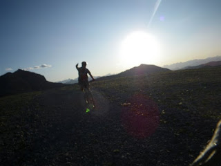
After the zig-zags, the false summit. This is a lovely open bit of ground and the point where the views to the west start to open up. Last night visibility was perfect and the mountainside deserted - for me this was what it's all about.


Eventually you have to ditch the bike and hike the last few hundred metres to the summit. The fire ranger Fun on the descentthere invited us to ride the path back down, but that looked like a sure route to blazing a new double-black diamond downhill course on the side of the mountain - we opted out. On the summit, it was hard to believe that 3 hours earlier I'd been at my desk looking across the foothills to this place.

After signing the visitors' book and a quick hike down, we bombed down the mountain in a third of the ascent time. The cobbles and gravel made for some tough riding, but what a fantastic place it was to ride!


Moose Mountain from gas trailhead. ~14.5 km. More pictures here.

View from the lookout helipad

Sunday 19 July 2009

Highwood Pass

Me, on the passWith less than two weeks before the Jasper-Banff ride I was feeling a bit under-prepared. Sure, I'd ridden 110 km (the length of the longest stage) through the foothills a fortnight ago, but I'd yet to stare over my bars at a proper Rockies mountain pass, and was concerned that my current combination of legs and cogs might be insufficient to get over the dreaded Sunwapta Pass on the Icefields Parkway. So I teamed up with Neil Campbell, a fellow Jasper-Banff rider, and we hit the Highwood Pass in K Country. Neil made a loop of the ride, from Barrier Lake to the first winter gate, but I had the advantage of a lift home waiting for me on the far side of the pass, and continued over the summit and down to Cat Creek, near the second winter gate, beyond. I'm glad of that - traversing the pass seemed far more satisfying than just reaching the summit.

Route mapThe first 40 km climbed and swooped continually, gaining overall height slowly to the winter gate. Approaching the FortressThere is a decent hard shoulder on Highway 40, and we were able to stay out of the stream of trucks and RVs headed to the campgrounds of Kananaskis. The views on this side of the pass were familiar, but great, as ever. Here's Neil near Evan Thomas, heading towards the Fortress.

We parted company at the first winter gate, and I checked in with the radio to make sure my lift home was still on, then dropped a few gears and started up the pass.

Starting up the pass properThe climbing wasn't too bad really, although my legs were sore at the top. I didn't put a foot down between Fortress Junction (about 38 km) and the summit (62 km). I stopped at the summit for a quick photo - this was my first ever mountain pass I think, certainly in Canada - and then tucked in my elbows and headed down the road deeper into the quiet country that lies beyond.
On the summit, 2200 mMy average speed on the 20 km after the summit was over 50 kmph. I was too tired to try pushing it very high, but it was comfortably close to 70 on the steeper stretches. There are no hairpins on this pass, so it's a joy to coast down and I had a big wind-stretched grin on my face for many minutes.

Eventually I reached Cat Creek at 97 km, in just under 4 hours of riding. After a lie in the sun and no sign of my lift home yet, I decided to ride a bit more, so I headed back up the pass, eventually meeting Lou at about 104 km. Now I feel much more prepared for the horrors of the Sunwapta - unless it snows that day!

More pictures from this ride are posted here.

Friday 17 July 2009

Sulphur Springs MTB

The weather has been pretty eventful this week. We had tornado warnings in Calgary, and pretty much every day there has been a violent thunderstorm. You have to take your chances though, so Mark Nelson and I headed out on Wednesday night to do the Sulphur Springs MTB loop in the Elbow Valley.

The storms have affected the trails, and the results are not pretty. Run-off and interflow were still flooding numerous sections of trail, and in places the path had become a fast-moving watercourse. In other locations, deep erosion ruts have appeared, and loose cobbles dumped by flash-flooding litter the trail. This is a pretty sandy, well-drained trail compared to, say, Telephone Loop, so I reckon it'll be a while before the boggier trails are properly rideable again.

The loop itself is about 11 km and contains a lot of hills - the route is shown in the Gem Trek map extract - I had walked it previously but had somehow forgotten how lacking in flat sections it was. Flat sections mean puddles and mud anyway, so maybe not a bad thing. I'd just had a tetanus jab though, and I felt like crap all the way round. On the uphills I felt like vomming and the downhills shook the arm muscle where the jab had been, like a Staffordshire Bull Terrier with a rat in its mouth. The trail conditions didn't help, and I was very glad of my disc brakes, except when we almost ran into a bear, and the squealing of rim brakes might have come in useful. It's a great little ride though and one I'll do again, for sure.

Monday 13 July 2009

Elbow Loop MTB Ride

Enjoying Tombstone Pass summit before the descent The last couple of weeks has flown by, with yard work causing me more pain than all my other exercise types put together. The weather has been pretty hit and miss, too, with hot afternoons, thunderstorms, and tornado warnings. So it was great to get out for an MTB ride yesterday and blow off the cobwebs - especially since it's now less than three weeks to the Jasper-Banff ride.

Ian approaching Tombstone Pass summitThe Elbow Loop is a fantastic circuit. It's fairly long (44 km) and has a height gain of about 400 m over Tombstone Pass, but if you ride it anti-clockwise then there are no big hills to climb, and you get to ride the single track section downhill. Riding the other way means you have a continuous climb of several km approaching Tombstone Pass, and then a horrendous uphill to the summit. The views into the Front Ranges are awesome and for large sections of the trip you're unlikely to see many people. I rode this one with Ian Stewart, a friend from Northern Ireland, on his first ride this year - good riding, Ian! More pictures here.
Single track at the back of the loop
Single track section above Big Elbow river