Looking west from South Baldy, Kananskis Country

Looking west from South Baldy, Kananskis Country

Friday 29 July 2016

Hiking Mt Lougheed II and III

Hiking Mount Lougheed

Any Calgary skyline ticker (as I am almost proud to admit myself to be) will have eyed the series of serrated teeth that runs south from the Bow Valley towards Moose Mountain, and wondered (a) what they are, and (b) whether they are accessible. The chain starts at Big Sister, and runs through Lougheed's four peaks, Sparrowhawk, Bogart and Kidd. That's a lot of Big Scree, in anybody's book. 

Most of those mountains can be accessed by the non-climber, but some of the approaches are exposed and/or difficult. Fortunately two of Mt Lougheed's summits are reasonably easy to ascend, although it would be easy to do something regrettable on the approach. The route takes in Lougheed II (the main summit) and III (a fifteen minute addition). I think it's known as the Spirko Route these days. These peaks are sandwiched between Lougheed I ( a difficult, exposed, and potentially lethal scramble), and Lougheed IV, better know as Wind Mountain. There is a sketchy-looking scramble up that one too.


The approach to Mt Lougheed
The approach starts from the Spray Valley side of the range, winding its way up to a beautiful alpine valley. On the way we passed a verdant spring in the woods, and crossed the new High Rockies mountain bike rail that will connect Canmore to Kananaskis Lakes when completed.


The fairly-recent trail up Lougheed is faint in places.


Starting up Lougheed II (3107 m) from the green valley
After a pleasant valley approach, and a couple of creek crossings, the trail to Lougheed headed straight up a huge scree slope, into what appeared to be a dead-end wall of cliffs. Goodbye grass, hello scree! We soon passed the guys who you can see way up the slope; not that we were fast, it's just that they still had a long way to go when pictured.


Mt. Sparrowhawk from where the main Lougheed scree slope enters the cliff bands.
Escaping the cliffs was easy enough. The only hazard was ball-bearing scree on slabs, which persisted until we were a fair way up the ridge above. I was soon on the summit ridge, and opened up enough space to be able to photograph the others against the skyline as they traversed towards the main summit of Mt Lougheed.

Traversing rubbly slabs to the firmer rock of the summit ridge.


Mt. Lougheed
The northern summit: Lougheed I
For scale, spot the tiny figure outlined against the lake.
Mt Lougheed
Lougheed II is the sunlit lower peak in front of the shapely summit of Wind Mountain (Lougheed IV).
Being an admitted sad skyline ticker, I took the chance to run down Lougheed II and bag Lougheed III. It was a simple enough scree run. On the col I saw some frost polygons; I'd not seen those out here before, although I knew that people sometimes go down into the Sheep area to see them.

Mt Allen
You don't notice these folds when you're on Mt Allen
The voiews of the centennial Ridge were excellent, showing the folds that create the steeper parts of the descent when heading north from Mt Allen.

The summit ridge of Lougheed II
Centennial Ridge
An unusual view of the pinnacles on the Centennial Ridge of Mt Allen
Lougheed II
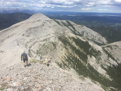
My companions Lindsay and Eric on top of Lougheed II, from Lougheed III.
This photo made Mt Lougheed appear suitable hardcore, but the truth is that the slope is not that steep - you can see the scree lines where I ran down to the col.
This guy appeared accustomed to hikers.
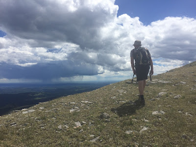
On the descent we ran into a large group of Chinese hikers; mothers and teenage kids huddled under an outcrop. They didn't seem very well equipped, or to know where the trail went, but I did not hear anything about a rescue. There was a good thunderstorm brewing, and after suggesting they might ant to keep an eye on it, we headed down as fast as we could.

Canmore spider
A huge spider (by Rockies standards). I cannot find out what it is.
Overall, it was a good day out. The valley below Sparrowhawk is worth visiting regardless of whether you intend to summit Lougheed.


North Ridge of Moose Mountain

A Hike-a-Bike up Moose Mountain's North Ridge

Moose Mountain occupies a huge sector of Calgary's mountain panorama. Most people who hike or bike up it do so from the southern well road ("the Moose Mountain Road"), off Highway 66. The problems with that are that: 

- It is a crowded route;
- Unless approaching via the Pneuma or Moosepacker trails, you miss out most of the ascent; and
- It only takes in part of Moose Mountain's skyline.

I'd done the tourist route many times, and had always regarded the other ridges with interest. This is my brief account of taking the North Ridge approach.

The route is described by Gillean Daffern, although this is a trip for which her compound approach to descriptions caused me some confusion. IMO it's best to just use the Gem Trek map, and forget the book, unless you want to extend the day substantially by taking cut lines etc. instead of the direct approach.

From the Pine Woods picnic area (washroom and non-potable water pump) we immediately took the wrong route. The map suggested that we could descend to a creek directly underneath the parking area, then pick up a cut-through trail to the Husky well road that would take us to the end of the biking section. Unfortunately, the 2013 flood removed a bridge here, so we started the day with wet feet. If you do this route, ride north from the parking lot for 500 m, until you reach the gated well road junction, then descend to a bridge, and continue towards Moose Mountain.

The road is about 14 km long. At least 13 km of it is uphill, and I ended up walking several times. The extra weight of hiking gear, boots, and water made quite a difference. Eventually, after passing several oil and gas facilities, we skirted the main site (the only staffed facility), and continued for 2 km uphill to the col and well pad below the north ridge. Partway up this leg, we noticed a cairn that I believe marked the faint trail to Jumpingpound Mountain. We dumped our bikes behind a berm, changed, and headed off uphill through some lovely meadows that offered great views. 

Cycling up the road to Moose Mtn North Ridge
Moose Mountain's north ridge, leading to the summit, seen from the interminable well road.
Hiking moose mountain
On the meadows where the North Ridge kicks up. It's raining in Calgary!
The summit of the North Ridge is only a little lower than the main summit.
The north ridge turned out to be a pleasant almost-scramble, along a narrow rocky ridge. Part way along there was a shovel standing upright in a cairn. I've asked around, but nobody seems to know the story behind this oddity. It's been there for a good few years.

Moose Mountain north ridge
Andy descends from the main summit, passing a memorial stone.
The final few metres were fairly steep, but the footing is OK, and after a short climb, the ridge met the main trail. On the descent we noticed a memorial stone (it's down past the fire lookout's biffy, if you want to take a look). 

Moose Mountain North Ridge
Lovely meadows on the descent, near the well pad.
The descent was insanely fast. Overall the trip included around 29 km of riding, and 4 km of hiking. It's not a long day per se, but the continuous uphill grind on the bike is sure to take its toll. Fortunately Andy had sneaked a couple of chilled beers into his cooler, so getting into the baking-hot car afterwards was a little easier than it might have been.

A short climbing story

Last year I attended a short writing online course at Mount Royal University, Calgary. The great thing about doing a writing course online is that you never meet your coursemates, so it's easy to post your stories without fear - it's effectively anonymous. The downside of the online format is that perhaps it doesn't pressure you to inject as much care into your writing as you would if you saw the readers every day in person. That's rather like this blog really! I'm going to pretend that I have an audience out there though, concealed behind their iPads and laptops. They just don't use the feedback button - unless it's to post spam...I get a few of "those" emails.

Here's one of the stories that I wrote on the course. The instructions were to write something that focused on interaction and dialogue between characters, in less than 500 words. I chose to write about climbing. Climbers don't talk a lot when they're on the cliff. They have to choose their words carefully to avoid miscommunication that could cause an accident. The story is a bit melodramatic, but I wanted to write something that the non-climbers on the course (i.e. everyone) would find interesting. Raving about threads and flakes, and extolling the virtue of the perfect hex placement probably wouldn't have cut it.

The photo accompanying the story is of a much younger me, leading Riders On the Storm in Pembroke, Wales. The sea was kicking up pretty hard that day, and made it one of the most memorable short routes I've done - or perhaps it's just this photo that keeps the memory alive, 20 years later.

Pembroke HVS climbing on sea cliff
Riders on the Storm, Pembroke, Wales


Ben

Susan steps smartly upwards into the sunlit safety of the stance. She clips a karabiner to a rusty pin, and yells: “BELAY OFF!” Her call is a bird that plunges at the booming sea, before swooping faintly beneath the jutting roofs to her partner’s perch. Unseen rope passes through protective palms, knots bend, and a life passes between hands, observed only by a hooded figure on the headland.

She exhales, relaxes, and pulls a sling from her neck. Safe again! Sweating. Shaken - but so alive!

“I’ve been looking for you”.

With a climber’s reflex she flinches forwards into the cliff, when another might have flipped into the space behind. Above her, Georgina’s curls whip darkly against the wind.

“Oh! Well shit. I’m glad I’d clipped; I nearly went the wrong way then. What’s up, George?” Air rises and falls around her like the waves below.

Georgina sends a shaded, insincere smile. “Just thought I’d check on you guys. How are you getting along with your new partner? ” She edges closer.

Susan shrugs. One hand feeds looping snakes of rope that flap and swing in space, until her partner’s lifeline tightens like a hawser. The ocean shakes the cliff; rainbows arc and fall like flying fish. She locks her belay device, relaxes. “Good, but he needs practice. I didn’t feel that safe leaving the last stance. Still, we made it OK. CLIMB ON!” Her shout tumbles end over end from sight; momentarily the rope comes alive and flows into her ready hands.

Across the gap, George slips into focus like a wary mongoose. “Oh. Sorry to hear.” Her eyes squint downwards into the seething maw; the endless, shifting ranks of whitecaps that besiege the wall. She looks back at Susan; staying silent until the sea’s roar subsides to permit her words passage. “So - was he any good?” She smiles again, falsely, steely; watching. The sky hangs still as stone beyond them.

Suddenly Susan is surrounded by screeching threats: the what-ifs, and she-knows surge from their stinking perches. Gravity pulls, and the wall lurches as if shaking her loose. Like a drunkard she grasps for steadiness. “You know?!”

George nods. “For a long time. You don’t have to say anything. It’ll be over soon. Poor Ben though. Really; it’s not him; it’s you.”

Her meaning is lost to the wind; too late, uncatchable. Susan’s mind scrabbles to fathom it even as she takes in slack rope and below her a figure emerges through the overhang, reaching high and swinging out above the seething sea. Understanding floods back suddenly. “Wait. George, no! You have it wrong. It’s not Ben.” George’s hand opens - in confusion, or bloody conviction? The jury of gulls explodes outwards as a ragged rock flies free to ricochet from the roof. Scarlet shards streak the wall, and a dead weight buckles Susan’s knees.

The sea falls silent; a faint cry carries from the headland. Wide eyes stare at the shocked onlooker, then two voices share his name.

Friday 15 July 2016

Low-Grade Banff Classics: Gooseberry and Rundlehorn

Gooseberry and Rundlehorn

I'm on a slow mission to tick the low-grade classics of the Bow Valley and Kananaskis. To save myself the effort of reading through the many guidebooks to the area and trying to define a list, I'm relying mainly on the web to identify the climbs; the easiest way to do this is to look at the routes used by the local guides. My thinking is that the routes up which they tow their paying clients are likely to be reasonably clear of loose rock, and offer decent belays.

Last week I did two of these climbs: Gooseberry (5.8) on Tunnel Mountain and Rundlehorn (5.5) on WEOR. The two climbs face each other across the embarrassment of an exclusive golf course (well, to be fair, it's fully inclusive if you have a thousand dollars to drop on a four-person game of motorized tiddlywinks) built within a National Park, and both are affected by the noise from the tannoy used to remind people that they are late for their tee-off. I can't think of anywhere else in the National Park where this would be allowed, but for some reason (hint: money) the Park makes an exception for golfers. I wonder for how long a climber might use a tannoy to make their belay calls before getting a ticket.

Oh well, the route's called Rundlehorn, not Grumblehorn, so I'll get on with a brief account of the climbing...

Rundlehorn rock climb
Rundlehorn (as seen from Gooseberry) climbs the narrow bedding plane slab that begins as a sparsely treed gully where Mt. Rundle intersects Tunnel Mtn on the photo above. Where the slab pinches out, it hops up a short wall to gain more easily-angled ground above.


Lou's first long-ish route of the year was to her liking; here she is leading off up the narrow Rundlehorn slab, on the fourth pitch.


Looking down the slab.


Tunnel Mountain crags in the background, above the river.


Lou leading one of the two best pitches of the climb, after the short wall that takes you off the slab.

Cascade Mountain

Lou with Cascade Mountain.

Banff Springs hotel

The upper pitches are quite photogenic.


Banff

Rundlehorn

Mt Rundle

After climbing, we had a quick paddle up the creek from near the "Banff Canoe Club" concession to Vermillion Lakes, but the water was really shallow and it was windy, which made for tough going in our solo boats. If your idea of wildlife is drunk teenagers doing dumb things in boats, then this area is a haven for spotting many varieties of that species!

Tunnel Mountain

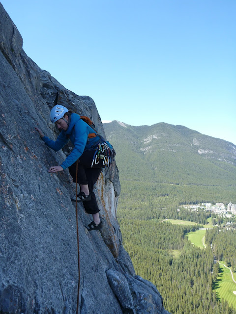
Looking down Gooseberry, about four pitches up. There are perhaps three cruxes on this climb, all around 5.8. I got the loose-looking flake on Pitch 2/3, which turned out to be alright. We broke the second pitch into two because of potential for rope drag around the entry to the flake/groove system.


Selfie while waiting for the call to climb, around pitch six or seven. The trees are starting to look small, which is a good reminder that despite being on Tunnel Mtn, and considered to be valley cragging, this is a decently long climb.

Tunnel Mountain

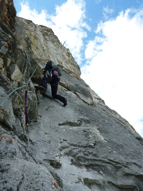
Lindsay seconding one of the 5.7 or 5.8 pitches near the top of Gooseberry. I found these pitches difficult, but the others though my lead was tough - I think I approach leading with a different state of mind to that I have when seconding, where I often struggle to engage fully with problem-solving.