
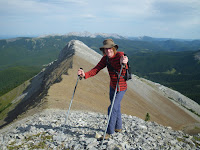
Belmore Browne (2,332 m / 7,649 ft) is a small summit about an hour from my home, with some great views. It's in a funny location, being close to Calgary, but off the surfaced road system, so it attracts few hikers compared to its neighbours to the north and south. It sits right on the edge of the Rockies, but gives some suprisingly distant views - we identified Mt Louis at about 50 km distance, from the summit of a nearby high point on the ridge.
Finding the start of the hike is a bit of a bugger. Even on descent, the trail simply peters out 100 m from the road. Advice given in Mike Potter's
ridgewalks book suggests driving 20.9 km from the highway 66 end of the Powderface Trail, then just picking up the track from there. The truth is that even from the road, which overlooks the logging corridor, the way is not obvious. We parked in a small pull-out at about 20.1 km and descended directly, crossing an old logging corridor and an area of muskeg, followed the muskeg downhill for maybe 100 m, then nipped over a small rise to join the proper trail, which was invisible from just 5 m away. Better would have been to follow the road north for about 4-500m, then as it turns to the right, following the hillside, just plunge downhill to a creek and follow it briefly downstream. Look in the creek for several logs that have been placed on the far bank, angling down into the water. Cross here and you'll find a path that suddenly starts. You can follow this path all the way to the col below Belmore Browne, as it's flagged with marker tape at all critical points. On the way up we followed paths around a couple of dry waterfalls, but on descent it turned out that the rock in these is excellent and it would have been better to scramble them.

Lou wasn't feeling great on this hike, so we made a full day of something that a fast party could easily cover in 3-4 hours, but it made for a lovely day out, and even on a Long Weekend, the closest we came to other hikers was briefly spotting a group on Tiara Peak above us. I have posted pictures of the trip and the views
here. Once you reach the col between BB and the main ridge, the rock gets better and there is a fun scramble to a minor high point to the left. On Belmore Browne peak itself, if you follow the ridge, there is superb rock just below the summit which gives a fun few metres of scrambling. From the summit, you can descend directly to the creek. The round trip is maybe 8 km with 650 m of ascent.

 Finding the start of the hike is a bit of a bugger. Even on descent, the trail simply peters out 100 m from the road. Advice given in Mike Potter's ridgewalks book suggests driving 20.9 km from the highway 66 end of the Powderface Trail, then just picking up the track from there. The truth is that even from the road, which overlooks the logging corridor, the way is not obvious. We parked in a small pull-out at about 20.1 km and descended directly, crossing an old logging corridor and an area of muskeg, followed the muskeg downhill for maybe 100 m, then nipped over a small rise to join the proper trail, which was invisible from just 5 m away. Better would have been to follow the road north for about 4-500m, then as it turns to the right, following the hillside, just plunge downhill to a creek and follow it briefly downstream. Look in the creek for several logs that have been placed on the far bank, angling down into the water. Cross here and you'll find a path that suddenly starts. You can follow this path all the way to the col below Belmore Browne, as it's flagged with marker tape at all critical points. On the way up we followed paths around a couple of dry waterfalls, but on descent it turned out that the rock in these is excellent and it would have been better to scramble them.
 Lou wasn't feeling great on this hike, so we made a full day of something that a fast party could easily cover in 3-4 hours, but it made for a lovely day out, and even on a Long Weekend, the closest we came to other hikers was briefly spotting a group on Tiara Peak above us. I have posted pictures of the trip and the views here. Once you reach the col between BB and the main ridge, the rock gets better and there is a fun scramble to a minor high point to the left. On Belmore Browne peak itself, if you follow the ridge, there is superb rock just below the summit which gives a fun few metres of scrambling. From the summit, you can descend directly to the creek. The round trip is maybe 8 km with 650 m of ascent.
No comments:
Post a Comment