
Just back from a gorgeous evening's riding southwest of Calgary. We rode the hill that I know as the Road To Nepal, but Natasha's club think that this road is the next hill to the east, which caused some confusion on our ride. I'm not sure who's right, and the name could apply to either road. Both are hilly, although only one of them has a fantastic view of the mountains from its summit (picture on left). This hill climbs steadily for about 5 km , then swoops down to meet what Lou and I call Coots' Ponds Road, and the circuit returns from there via 22X. I do have a reputation for underestimating distances on rides and hikes sometimes, and unfortunately tonight I excelled in this regard, and pronounced the ride to be 'about 16 km' in length. the final distance was a touch over 39 km, and I don't think Tara was amused at the extra 23 km, or the hills after the Road to Nepal that I'd conveniently forgotten about. Sorry! Next time I'll measure it out beforehand. It was a fantastic evening to be out on the roads though; the thunderstorms passed us by, and the views remained brilliant right to the end.

 Just back from a gorgeous evening's riding southwest of Calgary. We rode the hill that I know as the Road To Nepal, but Natasha's club think that this road is the next hill to the east, which caused some confusion on our ride. I'm not sure who's right, and the name could apply to either road. Both are hilly, although only one of them has a fantastic view of the mountains from its summit (picture on left). This hill climbs steadily for about 5 km , then swoops down to meet what Lou and I call Coots' Ponds Road, and the circuit returns from there via 22X. I do have a reputation for underestimating distances on rides and hikes sometimes, and unfortunately tonight I excelled in this regard, and pronounced the ride to be 'about 16 km' in length. the final distance was a touch over 39 km, and I don't think Tara was amused at the extra 23 km, or the hills after the Road to Nepal that I'd conveniently forgotten about. Sorry! Next time I'll measure it out beforehand. It was a fantastic evening to be out on the roads though; the thunderstorms passed us by, and the views remained brilliant right to the end.
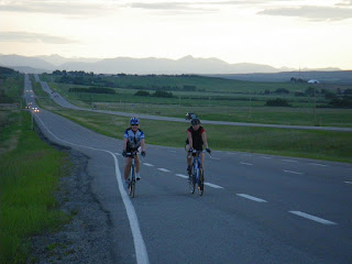
No comments:
Post a Comment